Click a link box below to jump directly to a topic.

GaLTT’s trail map

UPDATE MAY 2024: Edition 4.5 is out!
See our announcement post for more details.

Edition 4
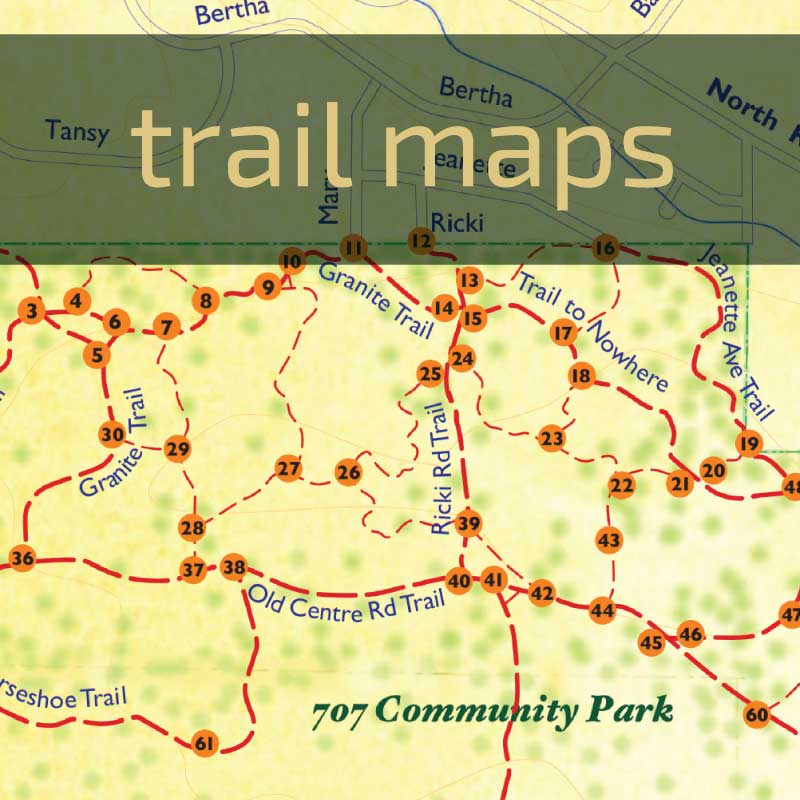
Our 2019 trail map includes many new trails added since the 2016 edition. In particular, 707 Community Park has greatly expanded and the RDN has installed new signage throughout the expanded park; trail intersections in the 707 have numbered posts that correlate to markings on GaLTT’s 2019 edition of its printed map.
The maps are printed on durable, damp-resistant paper. Copies are available from North Road Sports & Clothing store, Mid-island Co-op, the Visitor’s Information Centre (at 480 North Rd), Page’s Resort Group (Silva Bay Inn & Page’s Marina), and at the summer Farmers’ Market at Agi Hall. The reverse side includes a detailed map of the expanded 707 Community Park including the numbered signposts. It also describes 26 ABC walking routes, marked with letters on the main map. Scroll down to find the ABC walks on this page.
Unmarked or unmapped trails
Many well-used and beautiful trails on Gabriola (even some old logging roads) do not appear on GaLTT’s trail maps, which often puzzles trail-walkers. There are several possible reasons for this:
- the trail(s) may have been decommissioned by the landholder; or
- the trail(s) may be unauthorized by the responsible agency and we’ve been asked by them not to include it/them; or
- it/they may be (although previously used by the public) actually on privately-held lands not open to the public.
In answer to GaLTT’s request to include the trails through Elder Cedar Nature Reserve (which is owned by the Islands Trust Conservancy, ITC) on our trail maps, Kate Emmings, who is an Ecosystem Protection Specialist for ITC said:
“Trust Fund Board…does not restrict public access in its Nature Reserves. We do, however, try not to advertise them so that the use is kept light. In the case of the Elder Cedar Nature Reserve, we also have some concerns about advertising trails that lead off the property onto Crown Lands.”
In its drive to achieve public trail connections all the way between Descanso Bay and Drumbeg Parks, GaLTT continues to negotiate with private landowners, the Snuneymuxw First Nations, and Government departments for public trail access, but urges trail users to respect private land and Closed Trail notices. When on a trail that has been licensed for public use, please stay on the trail—the rest of the property is still private.
Respect and Care!
- Ours are multi-use trails. Expect to meet horse riders, cyclists, and walkers with and without dogs. Control your own dogs. Please be courteous toward other users.
- Be a “leave no trace” park and trail user: take away your trash and clean up after your pets. View wildlife from a distance. Take only photos, not wildflowers or plants.
PETROGLYPHS: Gabriola has many petroglyphs (stone carvings) with great cultural and spiritual significance to the Snuneymuxw and other First Nations. They record important events or locations, and relate to sacred practices, so please do not take rubbings or photograph them. Some petroglyphs can be found behind Christ Church, where there is an interpretive sign about them. Treat petroglyphs with respect: Do not walk on the fragile images and keep pets off them. They weather quickly when exposed, so do not scrape off moss and lichen. The Gabriola Museum has a collection of reproductions you may view.
Other maps of Gabriola trails
On-line maps & cell coverage
BE AWARE: Many areas on Gabriola have spotty or absent cellphone connection. Do NOT rely on it.
Where there is cell-phone coverage, users can access on-line and/or interactive trail maps while walking and reference their own locations.
- The Regional District of Nanaimo has great resources on their GIS Mapping page. They have both an interactive online webmap (mobile-friendly but requires a data connection, so this will not work everywhere) and a geo-referenced pdf of the 707. Both of these maps include the 707 signpost numbers.
- You can download Sensitive Ecosystem Maps (SEMs) from the Islands Trust website.
- You can download a pdf of GaLTT member Nick Doe’s personal maps of 707 Community Park and Coats Marsh Regional Park area trails; they come with many interesting notes and details and are superimposed on Google maps. NOTE: Many trail names used by Doe are different from those used in RDN and GaLTT maps.
Many apps are available now for smartphone-using hikers. Most use OpenStreetMap data for baseline information on trail locations. If you are using these apps, please be aware:
- Crowd-sourced information depends on people uploading data; not all trails on Gabriola are on OpenStreetMap.
- If your app doesn’t allow maps to be downloaded into your phone for offline use, you’ll need a cell connection to display them. Beware! Gabriola’s connectivity is spotty or absent in many places, you may find that your app won’t show where you are when you most need it.
Trails Atlas
One of our long-term projects is a Trails Atlas providing details about a variety of forest and beach walking routes on Gabriola. It will start with the routes from our Winter Walkabouts and the “ABC walks” described on our printed map. Each walk description will include a map, route directions, notes on what you will pass on the walk, and expanded information on the ecology, geology, and history of the landscape you travel through. It’s not done yet, but we hope to get there.
Safety tips
Be aware that cell phone coverage does not exist in some areas. A compass or GPS device may be helpful.
FIRES: Fire is the greatest threat to our island. During fire-hazard season (Apr. 1 – Oct. 15) campfires and smoking are banned in all parks and on trails. Never drop a cigarette or butt on the ground. Beach fires are not permitted without written permission from the Fire Chief’s office. When permitted at Descanso Bay campground, campfires must be in designated firepits. For more information: gabriolafire.ca
TRAILS: Our map shows only trails and beach accesses that may be legally and safely used. Not all trails are shown on this map—some lead to private property or develop naturally through wildlife use. Small trails come and go. Crown lands north of North Rd and west of Elder Cedar are particularly confusing.
Some trails have rough, slippery, or difficult sections. Wear appropriate shoes. Trail conditions vary between seasons; in winter puddles, mud, and slippery roots are common.
Please respect private property.
SHORE ACCESSES: Much of Gabriola’s foreshore is unstable and subject to erosion and winter storm damage. With the exception of those in provincial or RDN parks, shore access routes generally are informally created, remain undeveloped, and are not maintained. Be cautious if you choose to use them.
BEACHES: Stormy weather and changing tides often alter our ability to access or navigate Gabriola’s beaches, because huge driftwood logs are deposited or shifted.
- Be prepared for change and be very careful, as logs may shift dangerously as you clamber over them.
- In winter, exposed sandstone may be covered with very slippery algae, making it dangerous to walk on.
ROADS: Walk on the side facing oncoming traffic. Cyclists, please ride single file on our hilly, curving roads as there is often poor visibility for passing.
Great Winter Walkabouts
In late 2020/early 2021, while everyone was learning how to cope with the constraints of COVID, and with funding from the Gabriola Recreation Society and support and donations from North Road Sports, we introduced our “Great Winter Walkabout” self-guided walk series to encourage everyone to get out and about, discover new trails, and “walk into spring.” Gabriolans loved the idea and participated strongly—so we did it again in 2022. In 2023 and 2024 we introduced a series of guided winter walks. And in 2025 and 2026 we’ve returned to (mostly) self-guided walks.
You can find downloadable maps/info for some of these walks/series below.
2026: Favourite Trees Revisited
During the pandemic we began a tradition of offering self guided winter walks, providing walk descriptions with wayfinding guidance and information about what you’d see on the route. In 2021 we asked islanders to nominate their favourite trees (Several walks also refer to GaLTT’s Big Tree Registry.) This year we’re revisiting seven favourite tree walks with updated infosheets.
We’ll add links to these walks every two weeks as the pdfs are added—click to download.
- 707 Reforested – This walk offers clear day views of Vancouver Island and travels through mixed-wood forest, in which are situated three benches beautifully crafted by volunteer Jamie Doig, with maple wood donated by Charlotte and Tom Cameron, and installed by GaLTT work crews.
- S’ul-hween X’pey Forest bathing – A walk through S’ul-hween X’pey reminds us of the value of connecting to the earth.
- Descanso Cox Big Tree Hunt – This lovely walk offers water views of Descanso Bay and travels through the mature mixed-wood forest of Cox Community Park.
- Whalebone to Waterfall Loop – Featuring sword fern-lined forest trails with sea and mountain views towards the Sunshine Coast, Howe Sound and the North Shore, as well as glimpses of the occasional ferry.
- Heavenly Haven Woods – This beautiful walk through classic Coastal Douglas fir forest into Haven Woods is provided for us by two generous land holders who signed GaLTT trail licences and allow us to walk on their properties. Can you spot four fairy doors along the vanilla leaf loop?
- Entwined Trees Trail (Berry Point) – This walk offers quiet roads, a forest trail, ocean views and a diverse range of trees.
- Drumbeg Garry Oak Ecosystem – This walk offers forest and Garry oak meadow trails with lovely shoreline views towards Saturnina, Breakwater and Valdes islands. There are 2 picnic tables and 4 well- situated benches on this walk.
2025 Neighbourhood Pathways Winter Walks
GaLTT salutes the generosity of the many Gabriolans who have signed trail licences giving the public access to a trail on their property! Pathways on private lands provide critical connections between neighbourhoods, and contribute immensely toward GaLTT’s goal of establishing a network of trails from one end of our island to the other. This walk series explores some of those connections—click the walk names to download PDF route maps.
- Village Connections – this 5 km loop (highlighted in orange) crosses trail licences at the Gabriola Medical Clinic and Gabriola Commons as well as the Wilkinson Woods path, formerly a licence but now the newest addition to the 707 Community Park. The dotted orange line shows an alternative route through the Paisley Park panhandle which may be taken when construction in the area is finished.
- Nelder’s Gift – this route is accessed by a trail licence passing one of the loveliest spots on Gabriola, Nelder’s Pond, and then loops through federal lands held for the Snuneymuxw First Nation in the North Degnen Rd area.
- Balsam/Haven Connector – this route follows one of our newest trail licences (2024) from Balsam through Haven Woods and beyond.
- Presidents’ Walk – two important trail licences held by Past Presidents of GaLTT enable a big loop through the Malaspina neighbourhood and Cox Park.
- Berry Point Connections – an interesting and roundabout way to walk to xuwtiuqs (Orlebar Point).
- Robinson Woods to Merlin Trail – this route explores one of Gabe’s biggest conservation covenants and follows an important neighbourhood-connecting trail licence to find a viewpoint looking down the Trincomali Channel.
2022 Winter Walkabout—Gabriola’s favourite trees
NOTE: these walk descriptions have been removed because the flagging tape and trailhead rocks that guided people have been removed and some details may have changed. See 2026 – Favourite Trees Revisited for revised walk descriptions.
2020/21 Winter Walkabout—walking into spring
Click below to download each route:
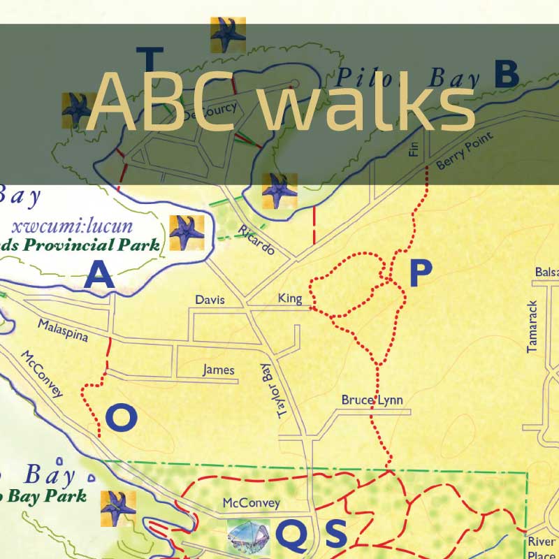
ABC walks
Our printed trail map has areas marked A to Z and the reverse side of the map includes 26 descriptions of walking routes near those locations.
- A to E are shoreline walks varying from 2 km to 8 km return.
- F to J are to viewpoints and shore accesses, mostly quite short, ~0.5 km.
- K to P are connector trails between different island areas, up to 10 km return.
- Q to Z are loop trails and routes varying from 2 km to 7 km. Some are entirely on trails, others include some road walking.
Shoreline walks
Gabriola has many shoreline walks, some more challenging than others. BEWARE: sandstone can be very slippery in winter.
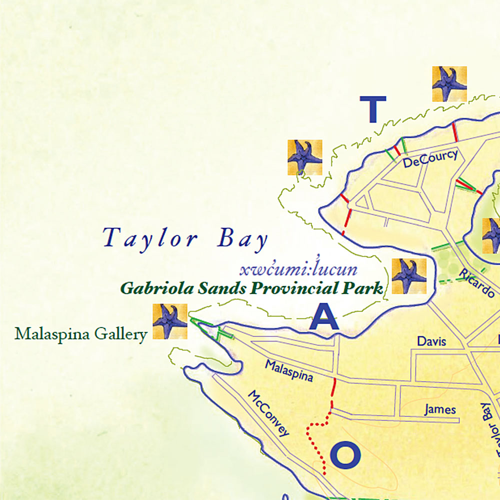
AMalaspina Galleries to Gabriola Sands Provincial Park
3 km return/mid to low tide/slippery in winter. Spectacular views, great sunsets. Malaspina Galleries were recorded by Spanish explorers in 1792. Access from end of Malaspina Drive; turn left to view the amazing sandstone formations, turn right to follow sandstone shelving to Gabriola Sands Provincial Park.
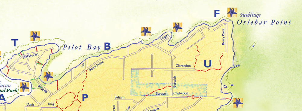
BGabriola Sands to
Orlebar Point
8 km return/mid to low tide/slippery in winter. Views of Entrance Island and north across Georgia Strait to the Sechelt Peninsula.
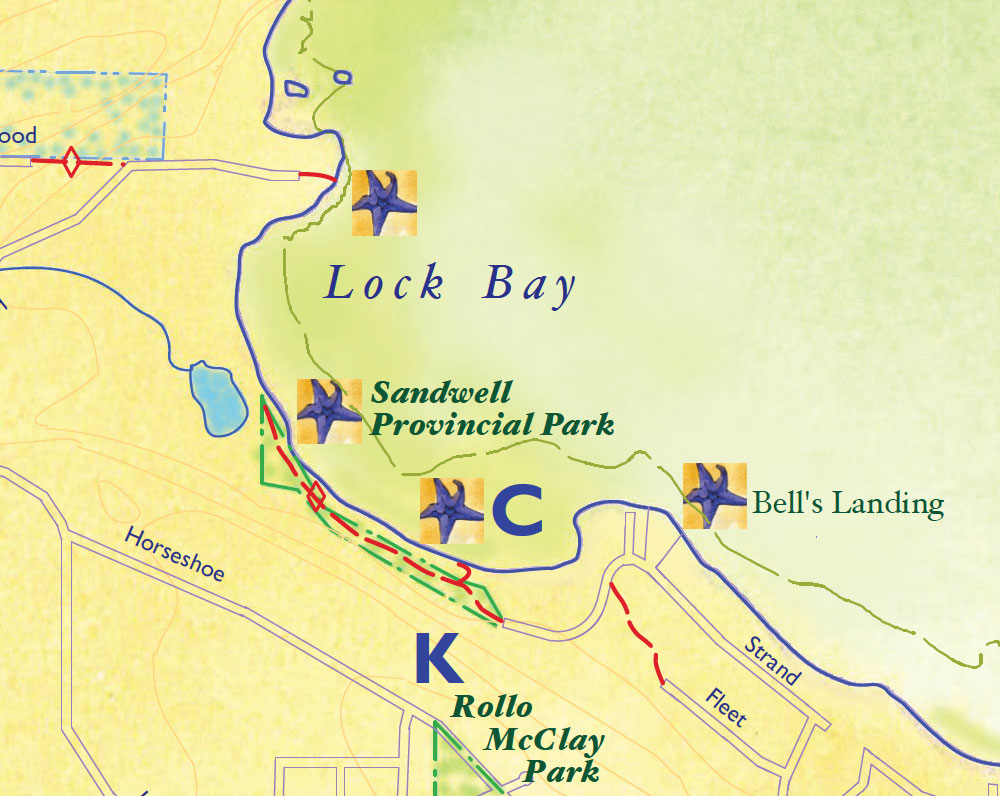
CBell’s Landing to Sandwell Provincial Park
2-3 km return, low tide. Sandwell has a pebble beach at high tide, sand at low. Soft muddy sand between Bell’s Landing and Sandwell.
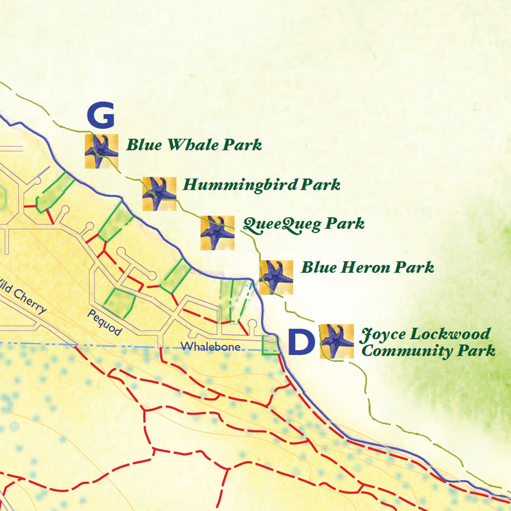
DJoyce Lockwood Community Park
Excellent for swimming and exploring. Cobblestone at high tide with rocky areas and a large sandy beach at low tide. Access by rough trails leading down from the trail running above the beach. At low tide you can walk back along the shoreline to connect to other Whalebone area community park accesses—look for yellow markers.
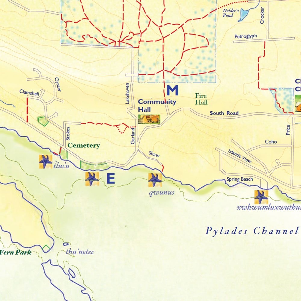
E
False Narrows sand bar to Spring Beach
5 km return/mid to low tides/some scrambling. Access from South Road at Stokes Road by Gabriola Cemetery; eroding shale cliffs, sandstone formations, winter waterfalls, views of Pylades Channel.
Viewpoints and shore access

Some public accesses lead to the shoreline, some lead to viewpoints. Look for yellow access markers.
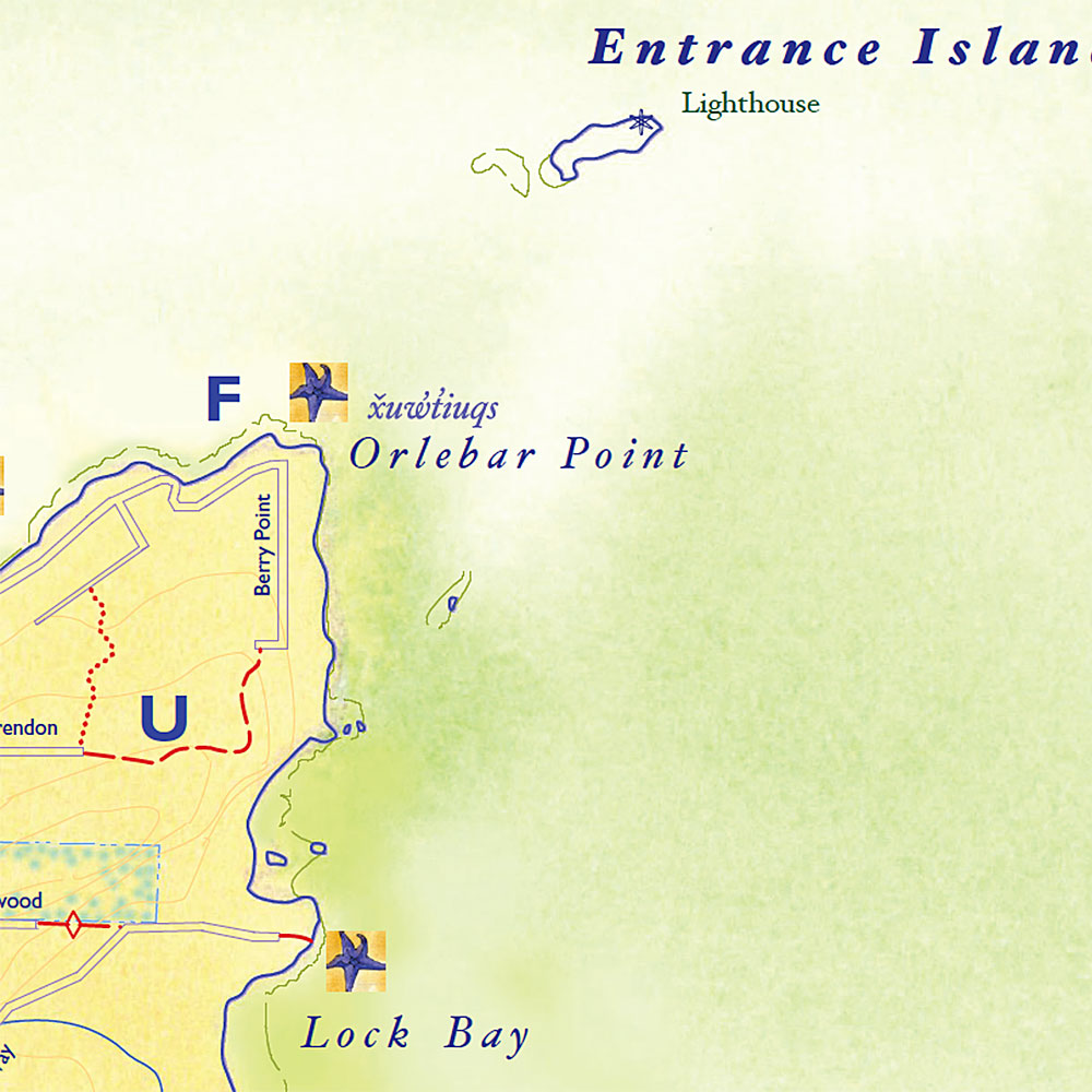
FOrlebar Point
Views of the mainland and of Entrance Island.
GWhalebone area community parks
Each park has a trail to a grass area, a lookout, and steps to the beach, best accessed at low tide, when you can follow the shoreline to Joyce Lockwood Community Park. Seasonal views of seal/sea lion haul-outs.
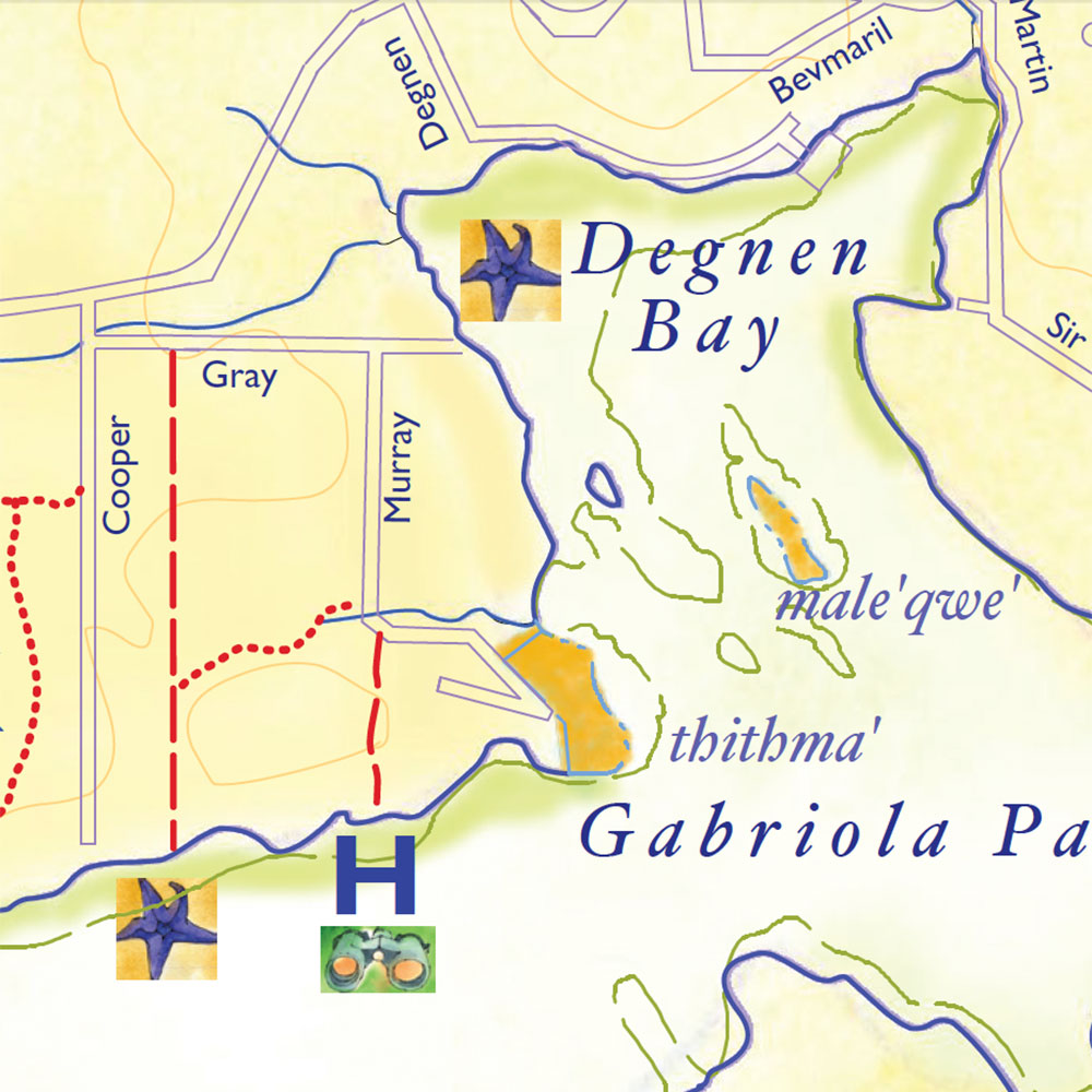
HMurray Road:
0.5 km return, no water access. Trail on this Murray Road right-of-way leads to the clifftop and a lookout over Pylades Channel.
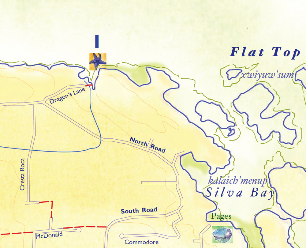
IDragon’s Lane
Short trail to beach access requires a scramble. From the end of Dragon’s Lane on the right, stay close to the fence (on your left) to avoid trespassing on private land. Views of Coast Mountains.
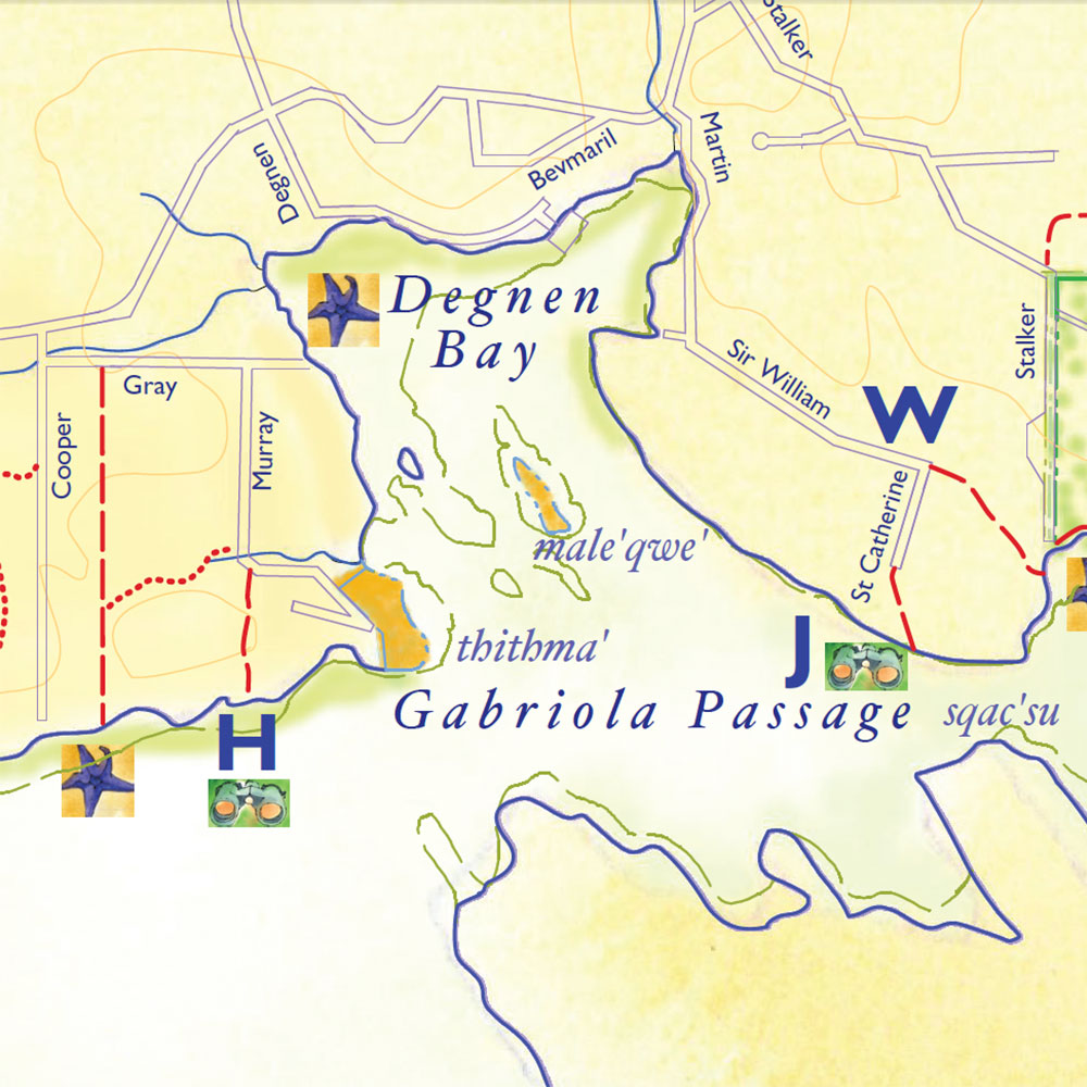
JGabriola Passage viewpoint
0.5 km return. Walk 100m down a public access driveway at the end of St. Catherines. Turn right at the sign onto a short trail to a lovely viewpoint.
Connectors
Many public or private trails provide opportunities for extended non-motorized walks or loops between different areas of the island.
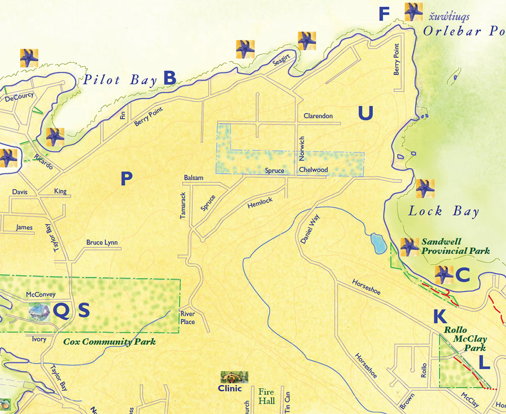
KRollo McClay Park to Orlebar Point or Twin Beaches
Up to 10 km return, mostly on roads. Walk via Horseshoe Road to Daniel Way and along it, then follow marked trail up steep hill to Chelwood. Walk straight ahead to Norwich and turn right to Berry Point Road. Either turn right again back to Orlebar Point, or walk straight ahead to Gabriola Sands Park (Twin Beaches).
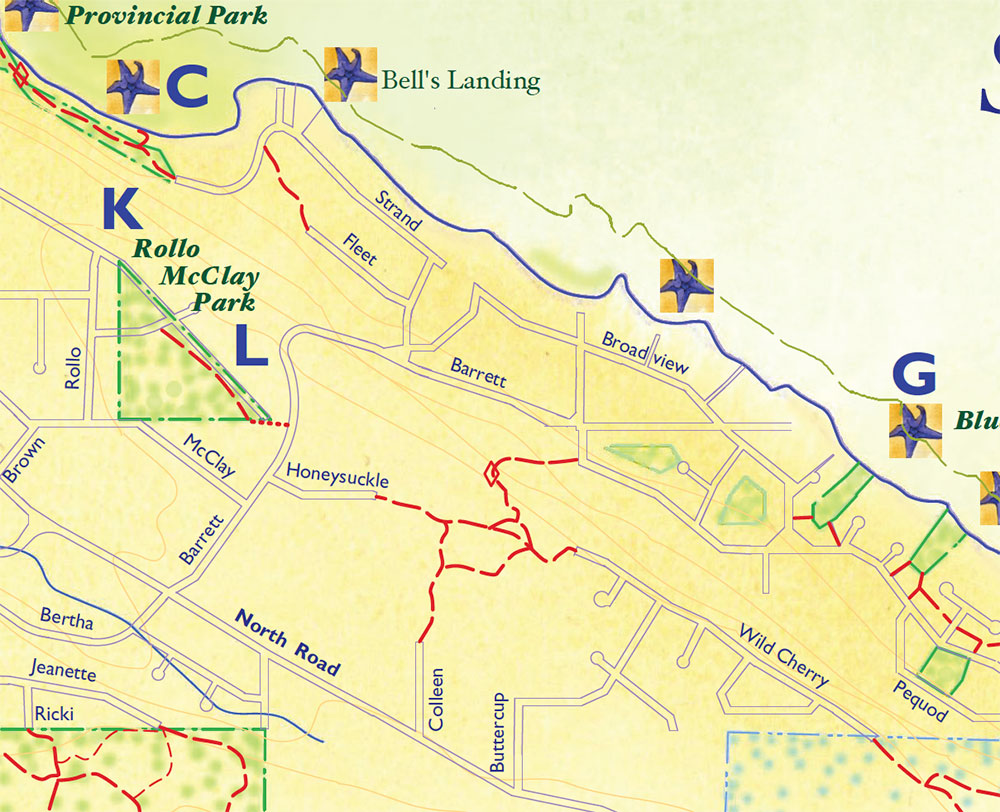
LRollo McClay Community Park
to Wild Cherry Terrace
Up to 10 km return, mostly on roads. Proceed along northeast side of park and licenced trail to Barrett Rd and turn right, then left on Honeysuckle Lane. At end of Honeysuckle, follow trail through forest to Wild Cherry Terrace. Note: from here you can extend your walk along Wild Cherry to enter forested Crown lands at the end of the road; there are connectors from this entrance down to Joyce Lockwood Community Park.

MSouth end South Road connectors
Trails from Crown lands connect to South Road near Wheelbarrow Nursery, or to Dorby Way via the Nelder’s Pond trail licence; from the Dorby/Peterson intersection short trails lead south to McDonald Road and then South Road. A side trail from Timber Lane connects McDonald Road to Cresta Roca Road.
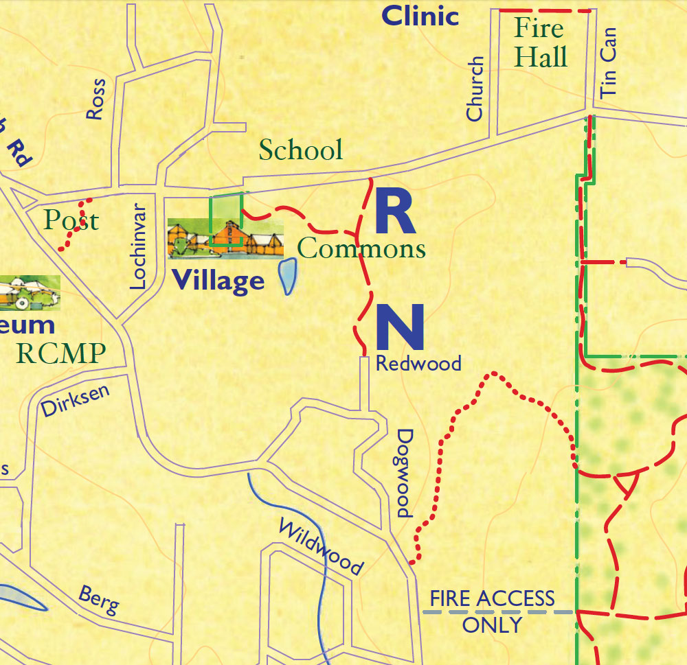
NCommons connector
From South Road on Dogwood Crescent to Redwood Road, and then by the boardwalk across a marsh to the Commons and Rollo Centre (or vice versa).
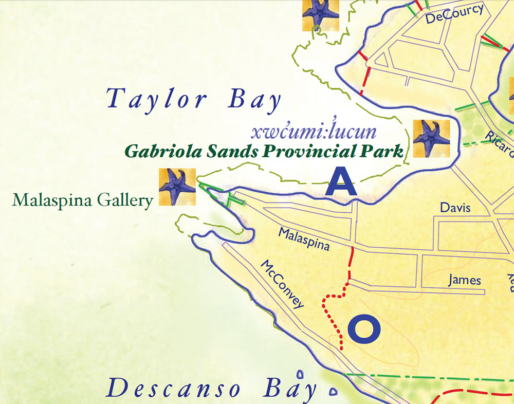
OMcConvey Road to Malaspina Drive
Follow a licenced trail from McConvey Road to James Way and walk a short trail to Malaspina Drive. Turn left to view the Malaspina Galleries.
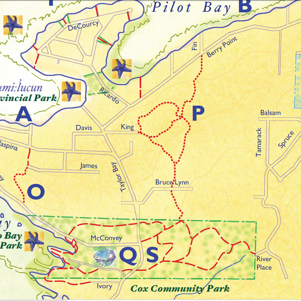
PHaven Woods
From the end of King Road, follow the trail to Berry Point Road (opposite Fin Road), or turn right on a trail to Vanilla Leaf Meadow and licenced connector trails to Bruce Lynn Drive and Cox Community Park.
Loop trails/routes
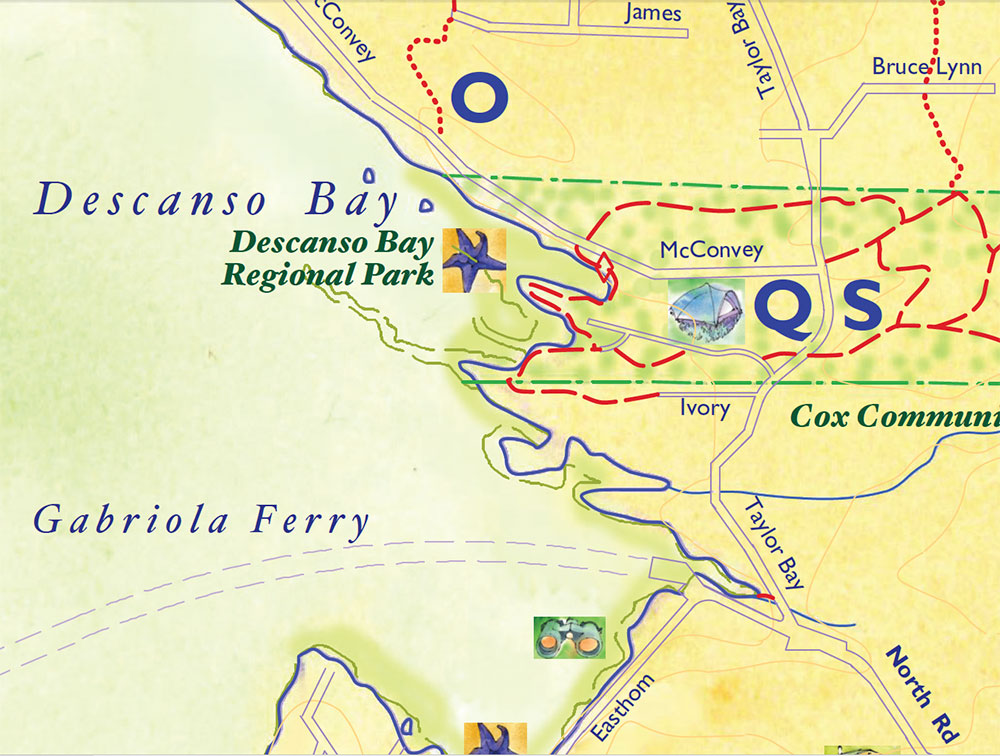
QDescanso Bay Regional Park
2-3 km, beach rock is slippery in winter. Features: views of Nanaimo and Protection Island, beautiful rock bluff trail to McConvey Road, connections to Cox Community Park.
Use the designated day use parking at the beach (through the campground); see park map there for detailed information. There are easy walks on the rocks around two bays and headlands. Trails connect to beaches, views, and a public right of way trail to Ivory Way. If you take the steep bluff trail to McConvey Road, cross there to find the marker for the McConvey trail to Taylor Bay Road, or for a shorter loop turn right down McConvey Road. At Taylor Bay Road turn right again to return to the Park entrance.
RThe Commons Trails
You are welcome to walk the trails on the 10-ha community commons, a former goat farm with a barn, timber frame shelter, yurt, labyrinth, orchard and pond. A boardwalk connects the buildings in the north to community gardens in the south. Take the trails leading through the forest in the west to discover a richly varied ecology. Enter from the Main or West Entrances off North Road or from Dogwood Crescent and Redwood Road from South Road.
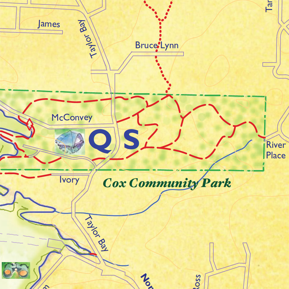
SCox Community Park
East of Taylor Bay Road
Variable lengths/some trails may be steep or rough. Features: Forest trails, cedar plank bridge crossing a wetland near River Place, pond viewpoint on Mallett Creek loop trail.
Yogi Trail Loop: Access from Taylor Bay Road at the pullout nearly opposite the road into Descanso Bay Regional Park. Head up the trail to the second intersection on the left and up a steep hill. Staying left at the next two marked trail intersections will return you to the first intersection you passed when setting out. Turn right to return to Taylor Bay Road.
River Place connector: From the Taylor Bay Road access, keep straight at all marked trail intersections all the way to a wooden bridge and up a hill to River Place.
Mallett Creek loop: From the Taylor Bay Road access, take the first right after setting out and follow the trail past a pond on the right. The trail intersects the River Place connector near the bridge. Turn left and follow the trail straight back to Taylor Bay Road.
Other connectors: (1) There is another trail marker between the Yogi sculpture and Bruce Lynn Drive; this trail connects the McConvey trail from Descanso Bay Regional Park to the Cox Community Park trail network. (2) There is also a licensed trail connector from Bruce Lynn Drive into Cox Community Park.
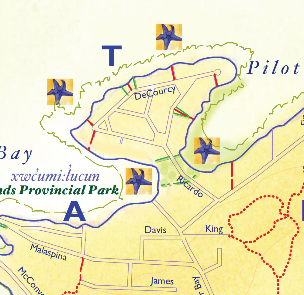
TTwin Beaches (Gabriola Sands) headland loop
2 km/variable terrain/slippery in winter/mid to low tides. Features: Ever-changing vista, interesting rock formations, swimming spots, and summer sunsets.
Park at Gabriola Sands Provincial Park and cross the road and grassy field to the Taylor Bay beach. Turn right to go clockwise along the Decourcy Peninsula shoreline. The beginning requires crossing soft mud and then a scramble over rocks to reach a flat sandstone shelf. The northern shoreline has vistas to Lasqueti and Texada islands and is easy walking till you reach the headland facing the Entrance Island light station. Go around the headland into Pilot Bay. After about 100 m look for wooden steps with a yellow concrete marker at the base; you will have to scramble up a large boulder to reach them. Follow a public access trail to the road; stay left at every fork to return to the starting point. For those who do not wish to do the scrambles at either end, there are other public access points on the map.
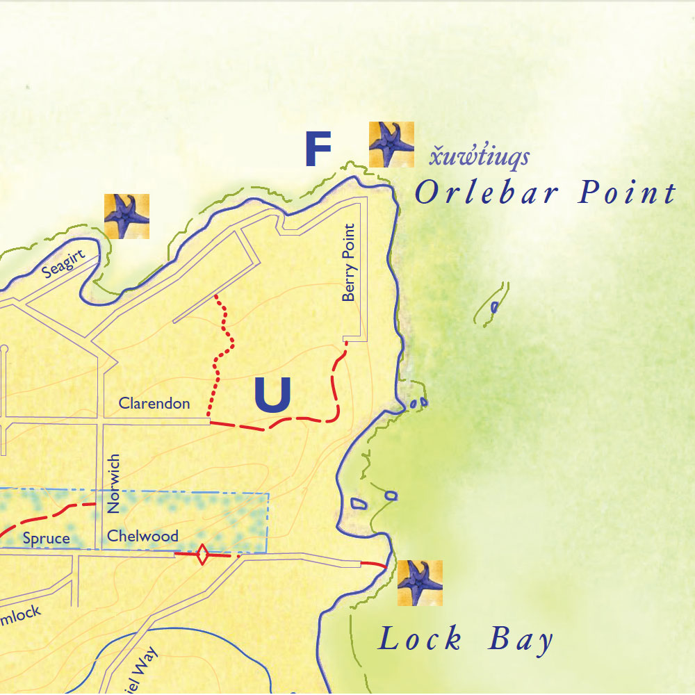
UClarendon to upper Berry Point Road loop
3 km, some on roads. Features: Views of Entrance Island and across Georgia Strait.
Park at Orlebar Point, where there are views of Entrance Island light station. Walk uphill on the gravel Upper Berry Point Road. Pass an orchard on the right with occasional glimpses east toward Vancouver on the left. Continue up the hill and past the turning circle on to a narrow public road that may appear to be a driveway. At a gate across the road, turn right onto the narrow forest trail. The trail is rough, with some exposed roots, and exits onto Clarendon Road, a quiet dirt road. Turn right onto Clarendon, and then turn right again on Norwich Road and walk down the steep, paved hill. Turn right onto Berry Point Road and head back to Orlebar Point, enjoying views across Georgia Strait to the Coast Mountains.
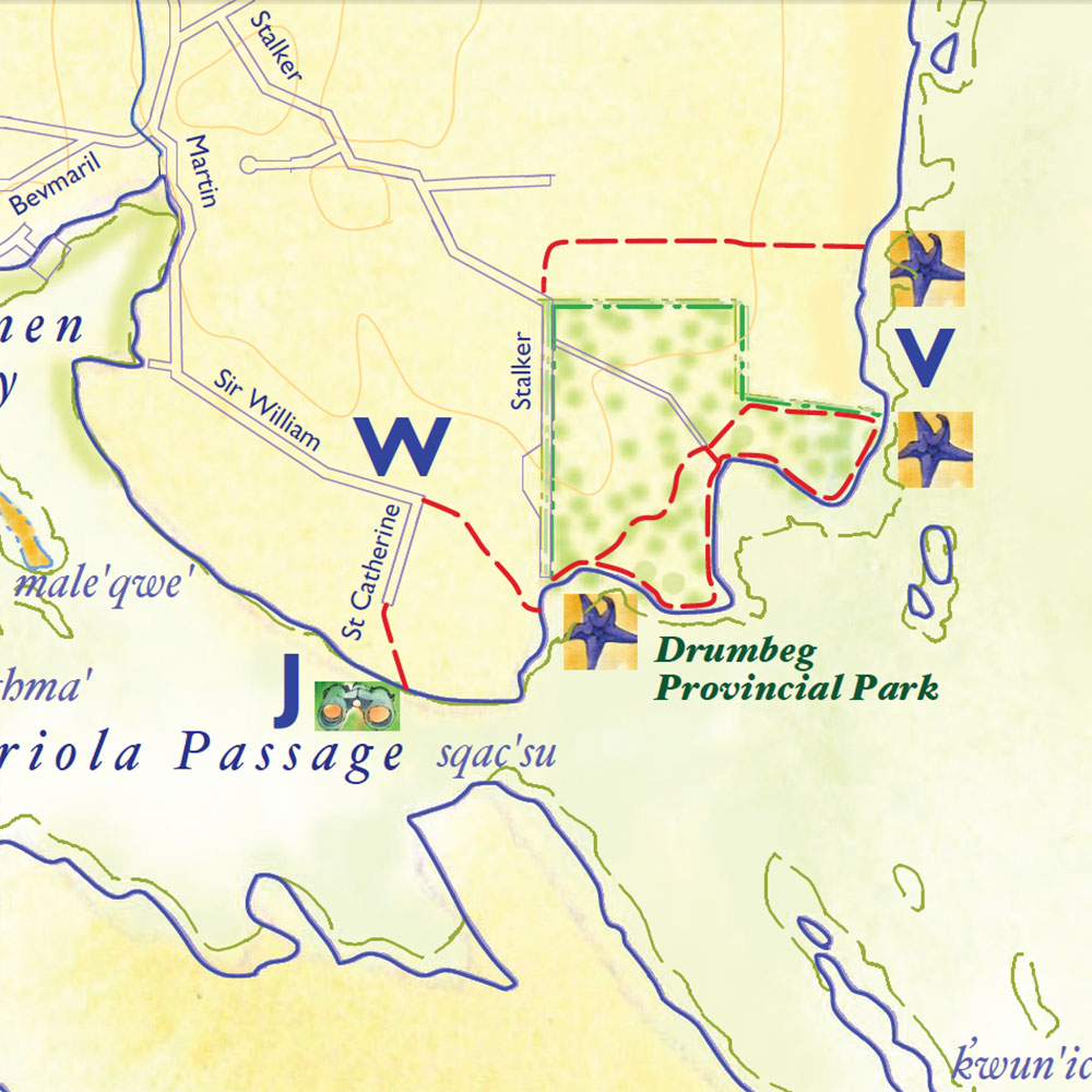
VDrumbeg Provincial Park outside loop
2-3 km/low tides/rock is slippery when wet. Features: Spectacular views, interesting rock formations.
Mostly easy trail and low-tide beach walk. Start at Drumbeg carpark. Turn left on the shoreline trail through a meadow to the last bench, which marks the park boundary. Climb down to the beach on shelving rocks. Continue along beach about 350 m, staying below high tide line to avoid trespassing. After the 5th house, look for yellow concrete public access marker and a yellow blaze in a tree by a split rail fence. Follow the trail through woods for about 1 km to a cross trail. Turn left and continue 200 m to Stalker Road. Re-enter Drumbeg by the park road, or add another 1 km to your walk by following Stalker Road to end; re-enter park by turning left on the trail above the beach to return to the carpark.
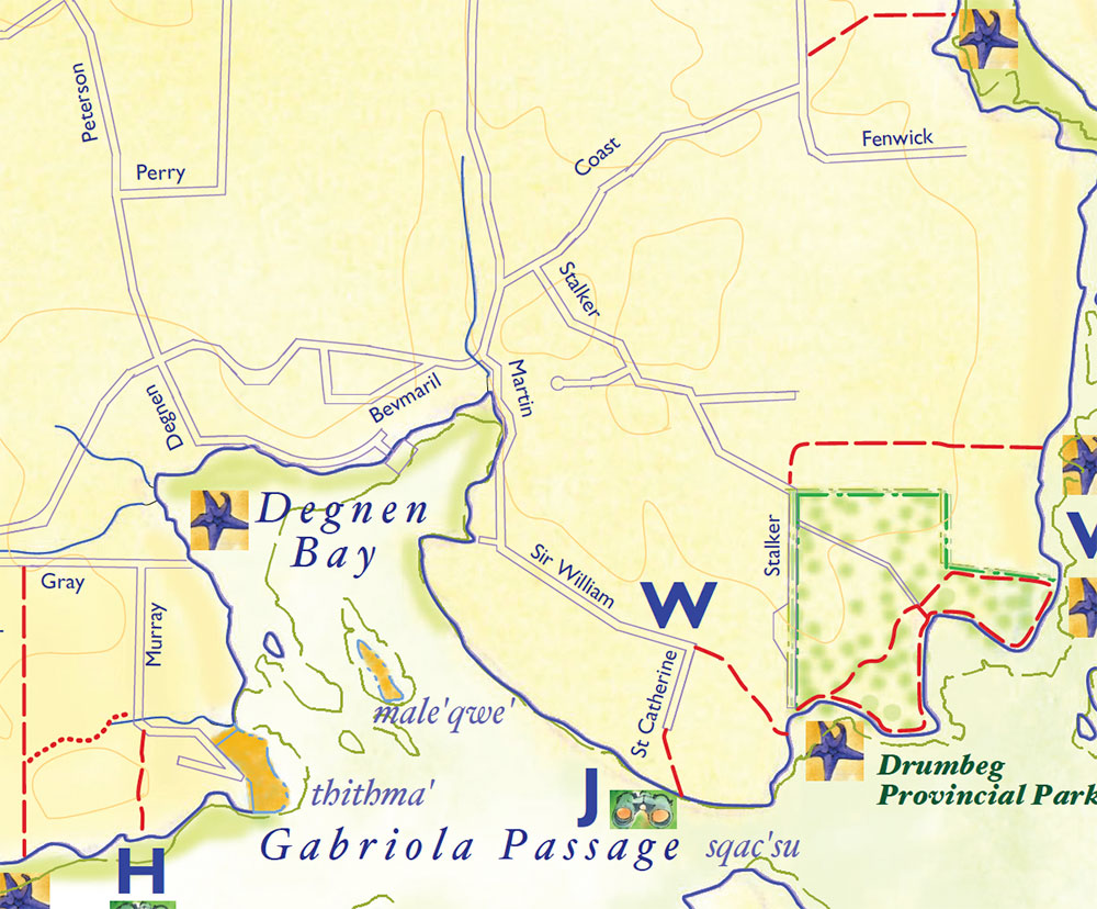
W
Drumbeg Provincial Park to Degnen Bay
About 7 km, mostly on roads. Features: Interesting rock formations, views of Degnen Bay.
Start at Drumbeg carpark and take shoreline trail to right to Stalker Road. Turn left down low bank to beach and follow high tide line 100 m further. Look for steps made out of car tires leaving the beach. At the top follow trail for 200 m to the end of a dirt road. Follow road about 300 m to the corner of Sir Williams Drive and St. Catherines Avenue. Turn right along Sir Williams for about 1 km to Degnen Bay, with its government wharf and many private docks. To reach the wharf continue to South Road; turn left and left again onto Bevmaril Crescent. After 100 m turn left on Maple Lane. At the top of the bluff take the narrow trail beside the fire hydrant to the wharf. Walk around the wharf to view the entire bay; look for sunflower sea stars underwater. From the wharf follow Degnan Rd along the shoreline to South Road and turn right to walk 1.2 km to Coast Road. From Coast Road turn right onto Stalker and either turn left down the signed main trail into Drumbeg Park or walk all the way to the water at the end of Stalker and then turn left on the shoreline trail into the park and follow it back to the carpark, or at low tide you may walk on the rock shelving below the trail.
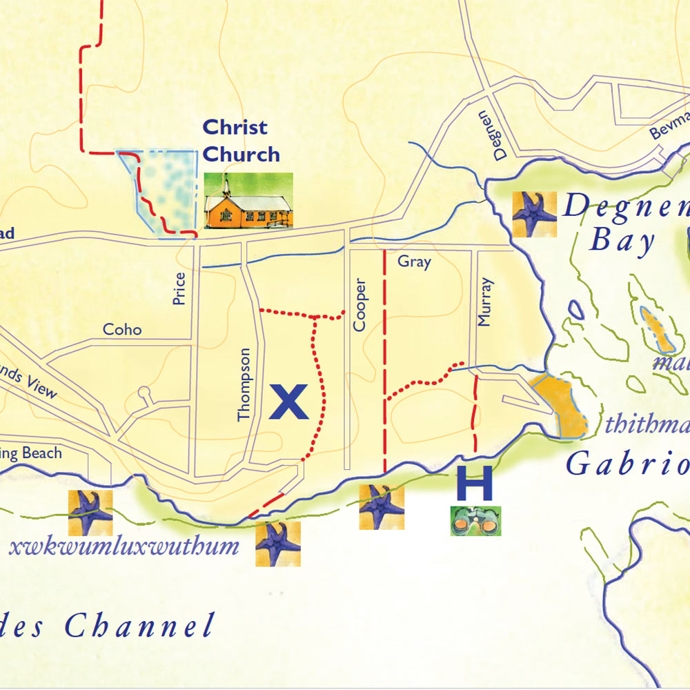
XPylades Channel loops
Distances are variable/may be steep/slippery beach accesses. Beach walks may only be accessible at low tide. Features: Lovely woods, shoreline views of Pylades Channel. Several trails and connecting routes can be accessed from roads south of Christ Church Gabriola.
Evans Road right of way: a 500 m trail from the yellow access marker on Gray Road south to the shoreline and a view of Pylades Channel.
Merlin’s Trail: a licenced trail leading east from Evans trail past a seasonal creek to connect to Murray Rd; turn left to follow the road back to Gray Road and the Evans trailhead.
Evans-Cooper loop: Follow Evans ROW to the beach and turn right. After a short distance, look for a yellow beach access marker that leads to Cooper Road. Walk on Cooper Road to Gray Road and turn right to the Evans trailhead.
Robinson Woods loop: Follow Evans ROW to the beach and turn right. Pass the Cooper Rd yellow access marker and continue to the Islands View Dr shore access marker. Walk up to the very end of Islands View Dr, then turn right onto the Robinson Woods licenced trail. Keep right at the posted intersection to Cooper Road. Turn left to Gray Road and then turn right to the Evans trailhead.
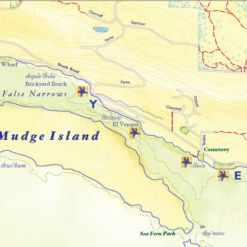
YFalse Narrows shoreline walk
4-5 km return, accessible at mid to low tides. Features: Views north to Harmac/Nanaimo, views south to Pylades Channel. Much birdlife in spring and winter; herons on low-tide mudflats year-round.
Access at Brickyard Beach, where bricks manufactured nearby until the 1950s were loaded for export from Gabriola and can still be found on the beach. There are oysters in the inter-tidal zone and much birdlife in the winter and spring. Turn left from the parking lot and follow the shoreline of False Narrows, where the tidal flow can be very strong. Across the channel is Mudge Island, the target of Canada Day potato cannons. Pass the boat launch and continue till False Narrows opens to Pylades Channel with a view of Valdes Island and other Gulf Islands. The mudflats are rich clam beds still harvested by the Snuneymuxw First Nation. Almost 2.5 km from the start you will see a wide track going up the slope from the beach to the Gabriola Cemetery. At this point you can retrace your steps along the beach or follow the trail up past the Cemetery and turn left to walk along South Road. You can also extend your southeasterly walk along the shoreline toward Spring Beach.
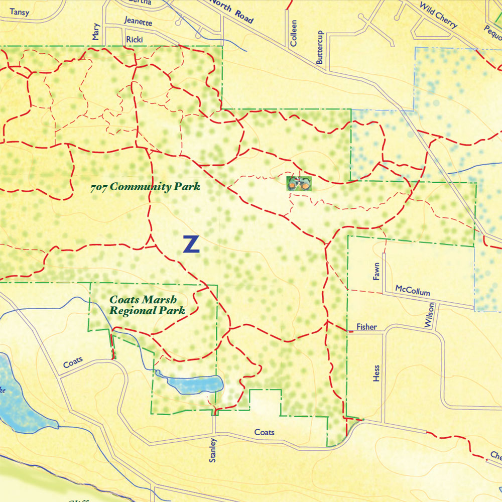
Z“Three Gates” trail loop in 707 CP
4 km. The 2018 expansion of the 707 Community Park added several established trails to the park, including the excellent loop offered by this now gateless trail. Enter the 707 at Fisher Road and after a short trail section turn right at post 84 onto the Coats Drive trail. Eventually at post 45 the Coats Drive trail will turn into the Old Centre Road trail. Stay left and then turn left at post 41, just before you get to the Ricki Rd trail. Follow this trail into a lovely second growth forest and turn left again at post 74. This leg of the loop leads back to the original Fisher Road access intersection.
